
Flatfiles for Mount Etna earthquakes
Summary: parametric table of the intensity measures and associated metadata of waveforms of the earthquake (ML ≥ 3) occurred in Mount Etna region in the time interval 2008-2023.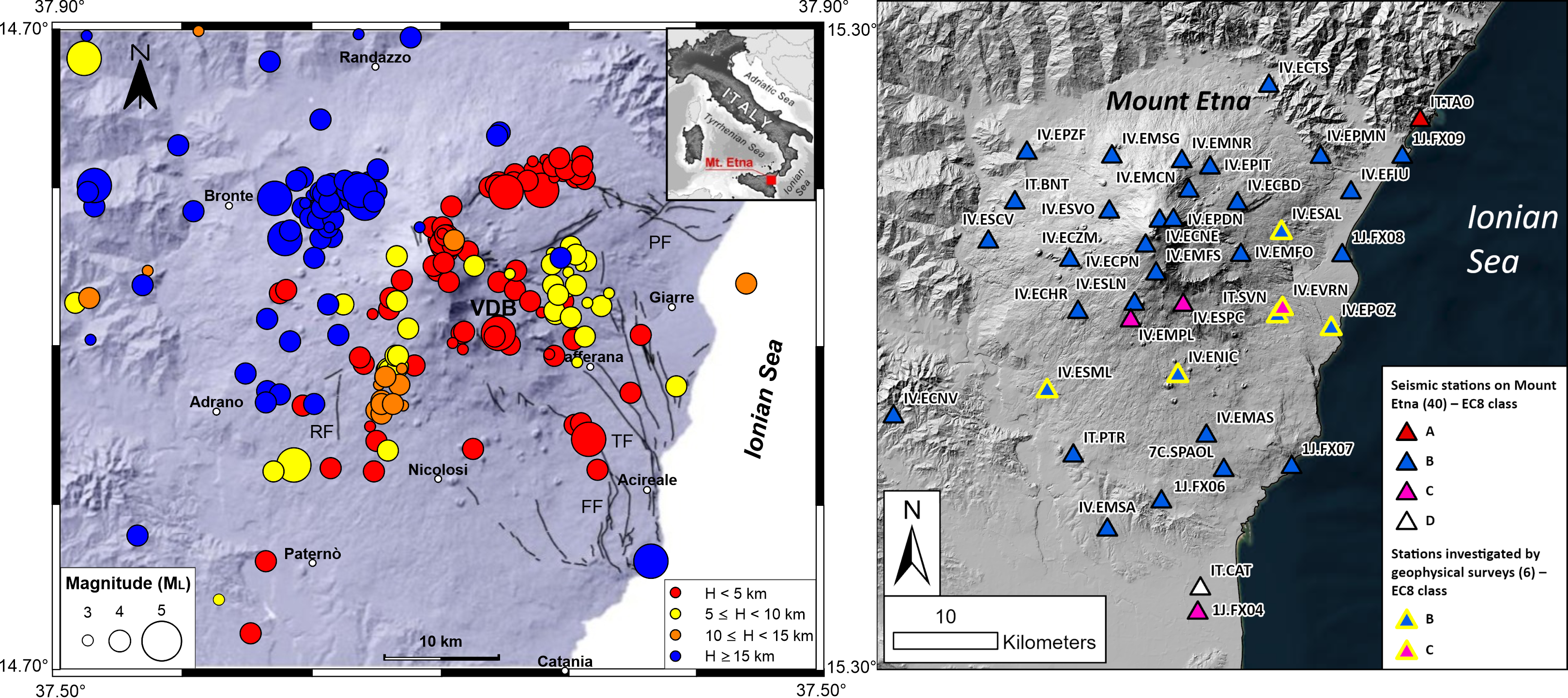 Description
The dataset includes 200 volcano-tectonic earthquakes with local magnitude ML ≥ 3.0 that occurred in the Mt. Etna region (eastern Sicily, Italy) between February 2008 and July 2023. Events were selected from the earthquake catalogue compiled by the Istituto Nazionale di Geofisica e Vulcanologia – Osservatorio Etneo, applying strict quality criteria on location accuracy and phase readings.
Waveforms were retrieved from the European Integrated Data Archive and from the Italian Civil Protection Department strong-motion network, covering four seismic networks (1J, 7C, IT, IV). All waveforms were visually inspected, manually picked, and processed through a uniform workflow including instrument response removal, Butterworth band-pass filtering, and signal-to-noise ratio quality control.
The dataset provides three types of ground-motion intensity measures, computed for the vertical (Z), north-south (NS), and east-west (EW) components: Peak Ground Acceleration (PGA) and Peak Ground Velocity (PGV); Fourier Amplitude Spectra (FAS) ordinates at 98 logarithmically spaced frequencies in the 0.05–47.20 Hz range; and 5%-damped pseudo-spectral acceleration (SA) ordinates at the same 98 frequencies.
Each record is accompanied by comprehensive event, station, and waveform metadata, including event location and magnitude from two independent catalogs (Osservatorio Nazionale Terremoti and Osservatorio Etneo), epicentral and hypocentral distances, station coordinates and elevation, filter corner frequencies, VS,30 and EC8 site classification at two levels of detail, NTC topographic category, and HVSR-derived site resonance parameters (f0 and A(f0)) for the subset of stations located in the Mt. Etna area.
Description of the zip file
The parametric tables Mt_Etna_Flatfiles.zip are distributed as a .zip file, containing:
- FAS/ folder with 98 files FAS_XXX.XX.csv (e.g., FAS_001.00.csv): one file per frequency, each containing the FAS ordinates of all recordings at that frequency, together with the full set of event, station, and waveform metadata;
- SA/ folder with 98 files SA_XXX.XX.csv (e.g., SA_001.00.csv): one file per frequency, each containing the SA ordinates of all recordings at that frequency, together with the full set of event, station, and waveform metadata;
- FLAT_PgaPgv.csv : containing PGA and PGV values for all recordings, together with the full set of event, station, and waveform metadata;
- README.txt : explaining all column headers and abbreviations used in the parametric tables.
- Mt Etna Flat files
- md5 checksum: 44d02c9c5f0b5a0c9ae91e21dc21606c
If you use the Mt. Etna flatfiles cite as::
Tarchini G., Brunelli G., Lanzano G., Tusa G., Felicetta C., Castelbarco T., Famiani D., Hailemikael S., Milana G., Paratore M., Spallarossa D., Azzaro R., Pacor F. (2026). Mt_Etna_flatfile: Parametric table of the intensity measures and associated metadata of waveforms of the earthquake (ML≥3) occurred in Mount Etna region in the time interval 2008-2023. [Data set]. Istituto Nazionale di Geofisica e Vulcanologia (INGV). DOI: https://doi.org/10.13127/volcanic_gm_data/mt_etna.1.0
Acknowledgments
This product was created in the framework of the project entitled “Attività di supporto al DRPC Sicilia per la prevenzione e riduzione del rischio sismico nell’ambito del Piano Regionale di Microzonazione Sismica per la realizzazione di studi Microzonazione Sismica, di cui al programma nazionale di prevenzione del rischio sismico (ex art. 11, Legge 77/2009)” coordinated by Centro di Microzonazione Sismica (CentroMS).
Related papers- Laurenzano, G., G. Brunelli, G. Lanzano, C. Barnaba, et al. (2026). Empirical amplification factors for seismic microzonation studies in volcanic regions: the study case of Etna mountain. Submitted to Annals of Geophysics.
- Tarchini, G., G. Brunelli, G. Lanzano, G. Tusa et al. (2026). Parametric table of recordings for seismological studies at Mount Etna: implications for seismic microzonation studies. Submitted to Annals of Geophysics.
 The datasets are licensed under the terms of the "Creative Commons Attribution 4.0 International (CC BY 4.0)" License. This means that you are free to share (reproduce, distribute, communicate to the public, publicly display, perform and play this material in any medium and format) and adapt (remix and build upon the material for any purpose, even commercially). The licensor cannot revoke these freedoms as long as you follow the license terms. You must give appropriate credit, provide a link to the license, and indicate if changes were made. You may do so in any reasonable manner, but not in any way that suggests the licensor endorses you or your use. You may not apply legal terms or technological measures that legally restrict others from doing anything the license permits.
Scientific: giovanni.lanzano@ingv.it gabriele.tarchini@edu.unige.it giulio.brunelli@ingv.it giuseppina.tusa@ingv.it
Technical: chiara.felicetta@ingv.it