
The 6th May, 1976 Friuli Mw6.4 earthquake: empirical shaking scenarios
Description
To reconstruct, with high spatial resolution, the ground shaking produced by the 1976 Mw 6.4 Friuli earthquake (ITACA event code IT-1976-0002), a predicted shaking scenario is generated using an advanced empirical model. The objective is to map the distribution of engineering Intensity Measures (IMs), such as Peak Ground Acceleration (PGA), Peak Ground Velocity (PGV), and spectral accelerations for different spectral periods (i.e. Sa(T=0.3s), Sa(T=1.0s)), over a spatial domain extending up to 80 km from the epicenter.
Methodology
The generation of the shaking field is based on an empirical approach that couples a Ground Motion Model (GMM) with site and spatial correlation models to reproduce not only the expected median values but also the correct spatial variability of the event, similarly to the NESK approach for generating shaking scenarios (Sgobba and Pacor, 2023), but here extended to an ergodic models with regionalised corrections. The predictions are provided without any constraint on the estimates of the observed parameters, being the latter very scarce at the age of the event and with low-quality recordings. The spatial computational domain is discretized using a grid spacing of 50 m, consistent with the spatial resolution of the VS30 map (Brunelli et al., 2025) used to model the local seismic response.
The computational workflow is structured in the following key elements:
- Ground motion model and regional corrections: The calculation employs the national model ITA18 (Lanzano et al., 2019), using input data for moment magnitude, fault geometry, and kinematic parameters extracted from the ITACA database (https://itaca.mi.ingv.it/ItacaNet_40/#/event/IT-1976-0002). To optimize the estimation for the specificities of the Eastern Alpine domain, regionalized corrective terms for the source and anelastic attenuation were applied to the base GMM (Brunelli et al., 2023). The distance metric used for propagation is the rupture distance (Rrup).
- Local seismic response modelling: To overcome the assumption of a homogeneous reference soil (rock with VS30 = 800 m/s), the spectral estimation is applied site by site, using the linear scaling term with VS30 implemented in the GMM. This scaling uses an updated, high-resolution VS30 map, calibrated specifically for the Italian territory and based on a large number of geophysical measurements from regional seismic microzonation data (Brunelli et al., 2025).
- Spatial correlation of intra-event residuals: To provide a more realistic shaking field for damage and risk analysis, the spatial covariance of the ground motion (i.e., the tendency of nearby sites to exhibit similar deviations from the GMM median) needs to be considered. For this purpose, a Jayaram & Baker (2009) spatial correlation model is implemented. The correlation ranges used are explicitly recalibrated on Italian strong-motion data (Sgobba et al., 2023; Huang & Galasso, 2019), assuming an average value of the distance correlation equal to 30 km, both at short and long periods.
Results
The application of the described methodology generates shaking fields that reproduce the complexity and heterogeneity of ground motion. The figure below shows the resulting empirical scenario for some spectral parameters. The image highlights the surface projection of the fault plane represented by the black rectangle. From the analysis of the map, two fundamental aspects of the modelling emerge:
- The maximum peak acceleration values, represented in dark red (with PGA values locally exceeding 500 cm/s²), are heavily concentrated within and along the southern margins of the fault projection, consistent with the kinematic parameters of the fault.
- The shaking field does not degrade in a perfectly radial or symmetrical manner moving away from the fault. The presence of evident amplification and de-amplification patches — visible, for example, in the clusters of high values (red/orange) located south of the fault — is the direct result of integrating the spatially correlated model and the local stratigraphic conditions (VS30) in the pre-alpine region. This heterogeneity strictly quantifies how site effects and intra-event stochastic variability significantly alter the spatial distribution of shaking at a given distance from the source.
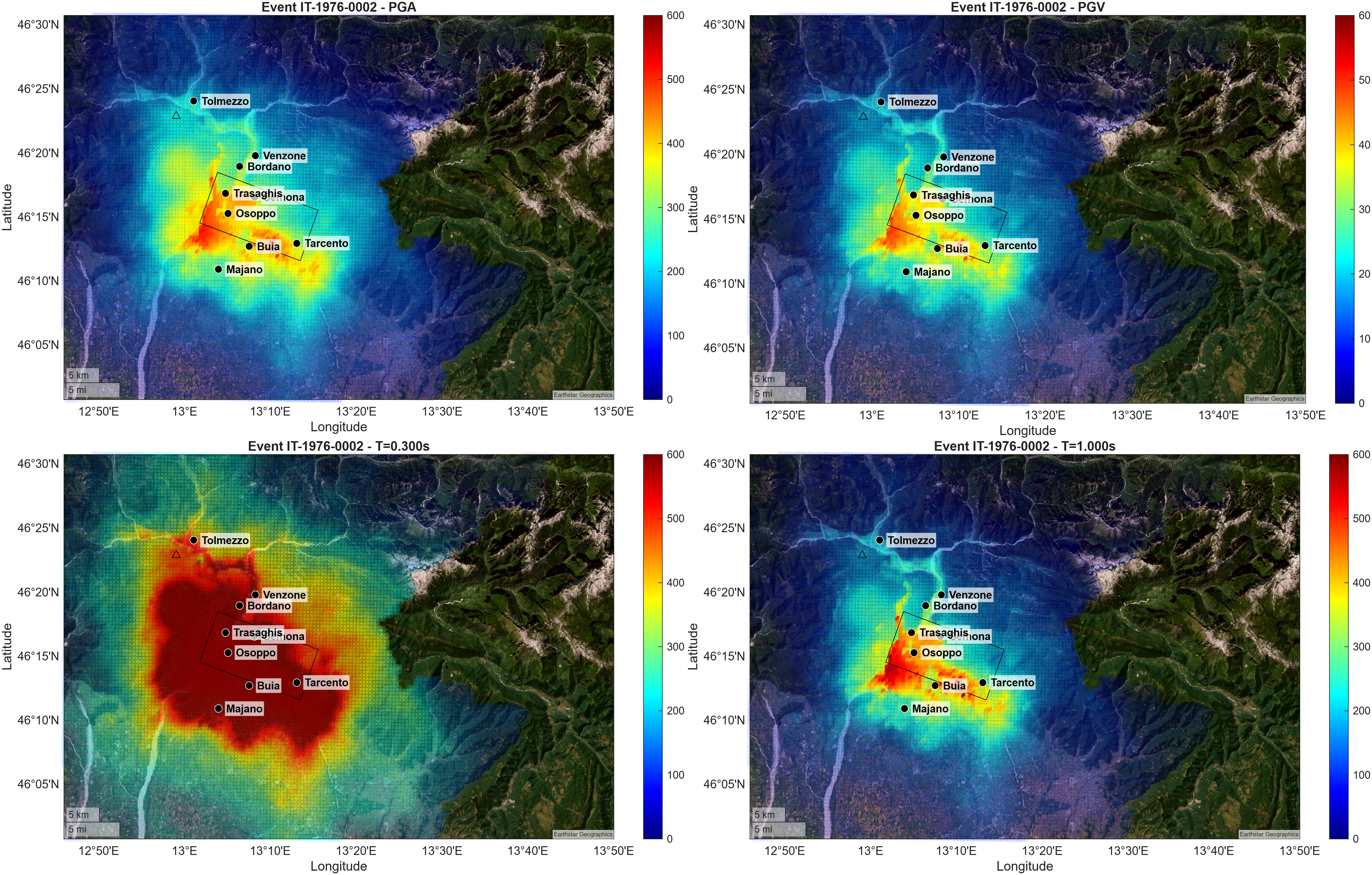 Figure: Empirical shaking scenarios for the 1976 Friuli earthquake (ITACA Event IT-1976-0002). The four panels illustrate the spatial distribution (50th percentile) of different ground motion Intensity Measure Types (IMTs): Peak Ground Acceleration (PGA - cm/s2, top left), Peak Ground Velocity (PGV - cm/s, top right), and spectral accelerations at periods T=0.3s (cm/s2; bottom left) and T=1.0s (cm/s2; bottom right). In each map, the rectangle indicate the surface projection of the fault plane. The simulations highlight the specific spatial patterns of each parameter, modelled by accounting for specific source and attenuation effects, local stratigraphic conditions, and intra-event stochastic variability through spatial correlation models.
Products
-
Friuli1976: empirical scenario of the horizontal components of ground motion for the 6th May, 1976 Friuli Mw6.4 earthquake.
The data are distributed as a .zip file, containing:- flatfile_Friuli1976.csv: a comma-separated values (csv) file containing the geographical coordinates of the grid nodes [°] according to WGS84 geodetic system (columns 1 and 2) and the median ground shaking parameters corresponding to peak ground acceleration (PGA, cm/s2), and pseudo spectral acceleration in [cm/s2] for periods T = 0.5, 1.0, and 2.0 s - columns 3, 4, 5, 6, respectively;
- readme_EN.txt (in English) and readme_IT.txt (in Italian) files explaining the abbreviations fields used in the flatfile
Citation - Brunelli, G. (2025) “Calibration of correction factors for source, attenuation and site effects to predict ground shaking across Italy” , PhD thesis. UNICAM International School of Advanced Studies at Camerino Università (37° ciclo) Physics, Earth and Materials Sciences. https://pubblicazioni.unicam.it/handle/11581/498511?mode=complete
- Brunelli, G., Lanzano, G., Luzi, L., Sgobba, S. (2023) Data-driven zonations for modelling the regional source and propagation effects into a Ground Motion Models in Italy, Soil Dynamics and Earthquake Engineering, Volume 166, 2023,107775,ISSN 0267-7261. https://doi.org/10.1016/j.soildyn.2023.107775
- Huang C, Galasso C. (2019) Ground-motion intensity measure correlations observed in Italian strong-motion records. Earthquake Engng Struct Dyn.; 48: 1634–1660. https://doi.org/10.1002/eqe.3216
- ITACA (ITalian ACcelerometric Archive). (n.d.). Event IT-1976-0002 (Friuli earthquake). Istituto Nazionale di Geofisica e Vulcanologia (INGV) https://itaca.mi.ingv.it/ItacaNet_40/#/event/IT-1976-0002
- Jayaram, N., & Baker, J. W. (2009). Correlation model for spatially distributed ground-motion intensities. Earthquake Engineering & Structural Dynamics, 38(15), 1687-1708. https://doi.org/10.1002/eqe.922
- Lanzano, G., Sabetta, F., D'Amico, M., Puglia, R., Pacor, F., & Luzi, L. (2019). A ground motion predictive equation for the Italian region (ITA18). Bulletin of Earthquake Engineering, 17(5), 2241-2274. https://doi.org/10.1007/s10518-019-00574-6
- Sgobba S., Pacor F. (2023) An application of the NonErgodic ground ShaKing (NESK) approach to an historical earthquake scenario: The case-study of the 1915 Fucino earthquake (central Italy), Soil Dyn. Earth. Eng. 164, 107622, ISSN 0267-7261, https://doi.org/10.1016/j.soildyn.2022.107622
- Sgobba, S.A., Faenza, L., Brunelli, G. et al. Assessing the impact of an updated spatial correlation model of ground motion parameters on the italian shakemap. Bull Earthquake Eng 21, 1847–1873 (2023). https://doi.org/10.1007/s10518-022-01581-y
If you use data available in Friuli1976.zip, cite as:
Sgobba S., Felicetta C., Pacor F. (2026). The 6th May, 1976 Friuli Mw6.4 earthquake: empirical shaking scenarios. Istituto Nazionale di Geofisica e Vulcanologia (INGV). https://doi.org/10.13127/gmm_scenarios/1976_friuli_scenario
References
License
 The Friuli1976 ground shaking scenarios are licensed under the terms of the "Creative Commons Attribution 4.0 International (CC BY 4.0)" License. This means that you are free to share (reproduce, distribute, communicate to the public, publicly display, perform and play this material in any medium and format) and adapt (remix and build upon the material for any purpose, even commercially). The licensor cannot revoke these freedoms as long as you follow the license terms. You must give appropriate credit, provide a link to the license, and indicate if changes were made. You may do so in any reasonable manner, but not in any way that suggests the licensor endorses you or your use. You may not apply legal terms or technological measures that legally restrict others from doing anything the license permits.
Disclaimer
This site provides access to empirical shaking scenarios for 1976 Mw 6.4 Friuli earthquake. Although all the parameters have been checked by analysts, no warranty, implicit or explicit is attached to the data. Every risk due to the improper use of data or the use of inaccurate information is assumed by the user.